God's Pocket
This was a 6-day trip to the God's Pocket area off the northeast coast of Vancouver Island. Prior to the trip we held a planning meeting to review individual responsibilities, develop our trip plan, our paddle plan and our travel plans to Port Hardy, British Columbia.
Saturday July 6th
Group members toured the town of Port Hardy, visited the museum, coffee shops, bakery and lone grocery store. Late afternoon we assembled at The Sporty (a local watering hole) to firm up the launch time, launch location (Carrot Park), review segment leaders and parking for the trip.

Sunday July 7th
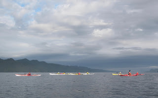
Our 9-person group hit the water at 7:30 am under calm winds and fair skies. Our first team of leaders took us to Duval Point, then we made a left turn up Goletas Channel to Songhees Creek arriving at 9:45 am. This is a beautiful location with a year-round water supply, wilderness camping and two black bears to welcome us. Mother bear was showing junior how to search for tasty treats along the shoreline. The plan was to have our second set of leaders take us across the 2.5-mile-wide Goletas Channel, which was covered with thick sea fog to Nolan Point. Nolan Point was our planned camp location for the duration of this trip and would serve as a home base for our daily paddles. After a half hour stop Songhees Creek the fog began to lift and Nigei, Balaclava, Hurst and Bell Island appeared to the east of us. We crossed over to Noble Islets, then adjusted our course to Nolan Point. Nolan Point had a couple sets of paddlers camping on the point so we moved up Browning Passage to a site in the woods capable of accommodating the nine of us, and it was perfect for our group. We spread out our tents, set up the cooking traps under a canopy of massive conifers and had our new home away from home established at 12:45 pm. (Paddling distance: 11 miles)

Monday July 8th
We were awaken by the shrill squawks of a juvenile raven that for the duration of our stay at Nolan Point spent mornings with us whining for food from its parents. Lots of eagles also inhabit this location. Also quite noticeable was the amount of wolf scat in the area. The sea wolves are a subspecies that have adapted their diet to include seafood ( crabs, clam, mussels). Today's paddle will be a clockwise circumnavigation of Balaclava Island with a stop/visit to the Scarlett Point lighthouse. As we traversed the north side of Balaclava Island we had the opportunity to spot a sea wolf searching the rocky coast for its breakfast. Once at the lighthouse Ivan, the lighthouse keeper gave us the grand tour his domain, explained all the tasks he and his assistant are responsible for. We left Ivan with a couple jars of homemade jam and a bottle of spiced rum, we have a new friend for life! Back in our kayaks we were immediately greeted by a large group of porpoise and a humpback whale. Our journey down Christie Passage was very pleasant, we could see the God's Pocket resort on Hurst Island as we headed back to our campsite. Several of us tried our luck at fishing in Browning Passage and met with some luck catching several rock fish which were released. (Paddling distance: 9 miles)

Tuesday July 9th:
Today we paddled around the south end of Balaclava Island crossed Christie Passage over to the God's Pocket Resort. No visible activity at the resort so we lined up our boats in front of the resort and took several obligatory pictures then moved on. Paddled clockwise around the rugged coastline to Harlequin Bay where stopped for lunch. This bay is well protected and has numerous campsites but the bay is shallow and at low tide can be a muddy slog out to deeper water. Again we saw whales, porpoise and sea otters while we paddled. (Paddling distance: 10.5 miles)
Wednesday July 10th
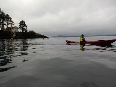
Today was our "water run" to a local water source at Clam Cove on Nigei Island. (note: yesterday late afternoon and most of the night we had a nice steady rain so we were able to capture all the water we needed for the duration of the trip.) Our paddle will take us up Browning Passage to Gordon Channel in Queen Charlotte Sound. The bay is approximately a mile long, with a fish camp and is a refuge for large pleasure craft, there was a big boat from Seattle anchored there. The creek is located at the end of the bay on a right hand side and had a nice flow to filter water from. On our return we paddled along Browning Wall ( goggle it ) and saw a good deal of sea life. Had a Humpback whale calf entertain us with some close by dives. This trip can be a windy/wavy paddle however today the seas where relatively calm. ( this paddle took us @ 4 hours).

Thursday July 11th
Today we paddled along the exposed side Lucan and Jerome Island on our journey to Port Alexander which is a deep, mile long bay on Nigei Island with a beautiful beach. Had a nice lunch break, long walk on this black shale beach as we waited slack tide and our slow paddle along Browning Wall. Amazing variety of sea life covers this steep rock wall. Dozens of different colored sea stars, anemones, mussel, translucent seaweeds, kelp, sea fans and many, many more. We also were visited by a grey whale which made several passes up and down the channel alongside us. (Paddling distance: 7 miles)
Friday July 12th
Say it ain't so! but we have to make our way back to Port Hardy this morning. Our
leaders for this leg of the journey have us up, packed and ready to go at 7:30 am. With no sea fog this
morning, calm seas and a high cloud cover it is the correct time to make the journey back to Songhees Creek. Numerous porpoise travel along with us, occasionally surfacing amongst our group. We stop at Songhees Creek for a bio and snack break (no bears to greet us this time).Our final set of leaders have us doing a shore crawl as we make our way back to Duval Point then turn right and head back to Port Hardy and civilization. (Paddling distance: ~11.5 miles)


Saturday July 6th
Group members toured the town of Port Hardy, visited the museum, coffee shops, bakery and lone grocery store. Late afternoon we assembled at The Sporty (a local watering hole) to firm up the launch time, launch location (Carrot Park), review segment leaders and parking for the trip.

Sunday July 7th
Our 9-person group hit the water at 7:30 am under calm winds and fair skies. Our first team of leaders took us to Duval Point, then we made a left turn up Goletas Channel to Songhees Creek arriving at 9:45 am. This is a beautiful location with a year-round water supply, wilderness camping and two black bears to welcome us. Mother bear was showing junior how to search for tasty treats along the shoreline. The plan was to have our second set of leaders take us across the 2.5-mile-wide Goletas Channel, which was covered with thick sea fog to Nolan Point. Nolan Point was our planned camp location for the duration of this trip and would serve as a home base for our daily paddles. After a half hour stop Songhees Creek the fog began to lift and Nigei, Balaclava, Hurst and Bell Island appeared to the east of us. We crossed over to Noble Islets, then adjusted our course to Nolan Point. Nolan Point had a couple sets of paddlers camping on the point so we moved up Browning Passage to a site in the woods capable of accommodating the nine of us, and it was perfect for our group. We spread out our tents, set up the cooking traps under a canopy of massive conifers and had our new home away from home established at 12:45 pm. (Paddling distance: 11 miles)

Monday July 8th
We were awaken by the shrill squawks of a juvenile raven that for the duration of our stay at Nolan Point spent mornings with us whining for food from its parents. Lots of eagles also inhabit this location. Also quite noticeable was the amount of wolf scat in the area. The sea wolves are a subspecies that have adapted their diet to include seafood ( crabs, clam, mussels). Today's paddle will be a clockwise circumnavigation of Balaclava Island with a stop/visit to the Scarlett Point lighthouse. As we traversed the north side of Balaclava Island we had the opportunity to spot a sea wolf searching the rocky coast for its breakfast. Once at the lighthouse Ivan, the lighthouse keeper gave us the grand tour his domain, explained all the tasks he and his assistant are responsible for. We left Ivan with a couple jars of homemade jam and a bottle of spiced rum, we have a new friend for life! Back in our kayaks we were immediately greeted by a large group of porpoise and a humpback whale. Our journey down Christie Passage was very pleasant, we could see the God's Pocket resort on Hurst Island as we headed back to our campsite. Several of us tried our luck at fishing in Browning Passage and met with some luck catching several rock fish which were released. (Paddling distance: 9 miles)

Tuesday July 9th:
Today we paddled around the south end of Balaclava Island crossed Christie Passage over to the God's Pocket Resort. No visible activity at the resort so we lined up our boats in front of the resort and took several obligatory pictures then moved on. Paddled clockwise around the rugged coastline to Harlequin Bay where stopped for lunch. This bay is well protected and has numerous campsites but the bay is shallow and at low tide can be a muddy slog out to deeper water. Again we saw whales, porpoise and sea otters while we paddled. (Paddling distance: 10.5 miles)
Wednesday July 10th
Today was our "water run" to a local water source at Clam Cove on Nigei Island. (note: yesterday late afternoon and most of the night we had a nice steady rain so we were able to capture all the water we needed for the duration of the trip.) Our paddle will take us up Browning Passage to Gordon Channel in Queen Charlotte Sound. The bay is approximately a mile long, with a fish camp and is a refuge for large pleasure craft, there was a big boat from Seattle anchored there. The creek is located at the end of the bay on a right hand side and had a nice flow to filter water from. On our return we paddled along Browning Wall ( goggle it ) and saw a good deal of sea life. Had a Humpback whale calf entertain us with some close by dives. This trip can be a windy/wavy paddle however today the seas where relatively calm. ( this paddle took us @ 4 hours).

Thursday July 11th
Today we paddled along the exposed side Lucan and Jerome Island on our journey to Port Alexander which is a deep, mile long bay on Nigei Island with a beautiful beach. Had a nice lunch break, long walk on this black shale beach as we waited slack tide and our slow paddle along Browning Wall. Amazing variety of sea life covers this steep rock wall. Dozens of different colored sea stars, anemones, mussel, translucent seaweeds, kelp, sea fans and many, many more. We also were visited by a grey whale which made several passes up and down the channel alongside us. (Paddling distance: 7 miles)
Friday July 12th
Say it ain't so! but we have to make our way back to Port Hardy this morning. Our
leaders for this leg of the journey have us up, packed and ready to go at 7:30 am. With no sea fog this
morning, calm seas and a high cloud cover it is the correct time to make the journey back to Songhees Creek. Numerous porpoise travel along with us, occasionally surfacing amongst our group. We stop at Songhees Creek for a bio and snack break (no bears to greet us this time).Our final set of leaders have us doing a shore crawl as we make our way back to Duval Point then turn right and head back to Port Hardy and civilization. (Paddling distance: ~11.5 miles)

Comments
Post a Comment